
ISC-EHB Bulletin
NOTE: This is a brand new and improved release that replaces the original EHB. If you wish to use the original EHB please use this link.
What is the ISC-EHB Bulletin?
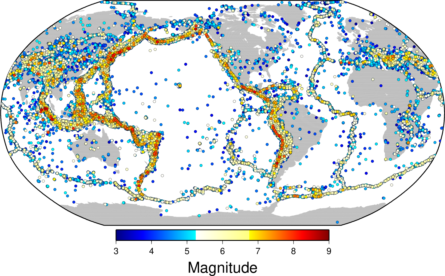
The ISC-EHB Dataset is a groomed version of the ISC Bulletin, and contains 208480 Seismic events from 1964 to 2021, where the period 1964-2008 has been rebuilt. The total number of 47206228 time defining seismic phases are associated with the ISC-EHB dataset. Teleseismically well-constrained events are selected from the ISC Bulletin, and are relocated using the EHB algorithm (Engdahl et al., 1998) to minimise errors in location (particularly depth) due to assumed 3D Earth structure.
Below is a figure showing the locations and magnitudes of the events:
Why use the ISC-EHB?
The ISC-EHB is a dataset of teleseismically well constrained events. To minimise errors in location due to assumed 3D Earth structure, seismic events are selected based on strict criteria (see below). The EHB algorithm incorporates a specific phase identification algorithm for teleseismic depth phases (pP, pwP, sP, PcP) as well as using PKiKP, PKPdf, PKPbc, PKPab. It is a valuable tool for:
- Seismicity studies; global and regional
- Tomographic inversions - low to high frequency
We do not advise using this dataset for seismic hazard studies or any other studies that require completeness to a certain level of magnitude.
How is it different from EHB?
The original EHB stopped in 2008, and since then the volume and quality of data has significantly improved. To take this into account we have updated event selection, data preparation and processing, and relocation procedures (described below). This enables us to produce a cleaner and more robust dataset.
We have applied this approach to events in 1964-2021, and this new dataset has replaced the equivalent years in EHB, (for a full description of this click this link). Over the next few years we shall go beyond 2021 to extend the ISC-EHB to the present day.
Searching the ISC-EHB database
The database covers years 1964-2021. The strength of the ISC-EHB is the constraint on depth, and some depths are slightly better constrained than others. This slight variation in depth constraint, depending on what you are using it for, may influence whether you use all or part of the dataset. To help with this decision we have split the depths up into three categories:
Level 1 (L1) - Free depth with standard error < 5 km, and at least 3 defining depth phases, OR fixed depth will be constrained by depth phases, OR by USGS broadband depths.
Level 2 (L2) - Free depth with standard error 5-15 km, OR a fixed depth based on the GCMT solution.
Level 3 (L3) - Free depth with error > 15 km OR fixed depth based on review of local/nearby seismicity, or seismic regions.
Level 1 can be thought of as the 'gold standard' of depths in this dataset, level 2 is slightly less well constrained and level 3 is the least well constrained.
We will add the depth categories as a new search criteria in the near future.
Maps and cross sections
New to ISC-EHB are cross sections of seismicity in subduction zones around the world. An example map and cross section for the Kermadec region is shown below. Click here, or on the map or cross section below, to see all maps and cross sections, and get more information.
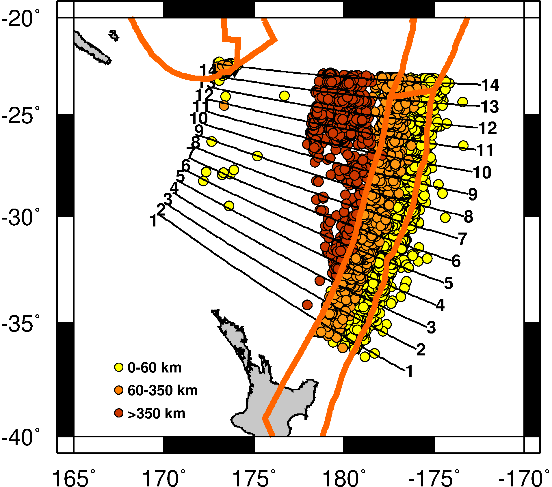
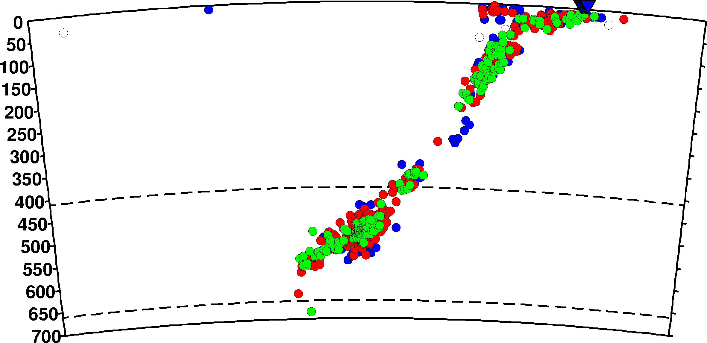
Cross section from Kermadec region
Updates
2018-02-01 Improvement in the magnitudes assigned to events for 2000 to 2013
2018-04-04 2014 Released
2019-04-15 2015 Released
2019-06-03 2016 and 1964-1999 Released, 1960-1963 Removed
2020-12-17 2017 Released
2021-09-02 2018 Released
2021-09-23 single event in 1976 updated (1976-02-14 10:50:21)
2022-08-05 Three events with a time change (previous times 2014-05-14 18:48:02, 2017-09-20 03:29:00, 2018-03-18 09:23:00)
2022-08-05 2019 Released
2023-06-22 2020 Released
2024-08-08 2021 Released
ISC-EHB Criteria and Procedure
To minimise the location bias produced by 3D Earth structure, events are selected from the ISC Bulletin only if they meet the following criteria:
They have > 25 teleseismic stations with a secondary teleseismic gap < 180°
They have a defining prime magnitude > 3.75 (Di Giacomo & Storchak, 2016)
Warnings!
In the RES files the latitude and longitude are in geocentric coordinates and NOT geographic as in HDF and the database.
Also in the RES files for tomographic applications you will need to add back in the patch correction (scor) to the observed residual (resid). This is an upper mantle "station" correction used only for location that is subtracted from the observed travel time (obstt).
Once selected:
- ISCloc (Bondar & Storchak, 2011) is used to obtain an initial solution.
- The EHB software is used to relocate all events using the initial ISC solution as a seed. For further information on the EHB algorithm please see 'EHB Algorithm' below.
- Near station (< 3) and secondary phase arrival residuals are reviewed and a depth is adopted or assigned according to best fit. In some cases the depth may be reassigned based on other sources (e.g., USGS broadband depths).
- The relocated events are plotted in subduction zone cross sections (taking into account the curvature of the zones) along with events from the ISC-GEM catalogue (Storchak et al., 2015).
- These plots are used to confirm or modify poorly constrained depths.
- The final database, maps and cross sections are released online.
EHB Algorithm
The following elements are included in the EHB algorithm:
- Use of the ak135 1-D travel-time model;
- Iterative relocation with dynamic phase identification;
- Use of first arriving P, S and PKP phases;
- Use of the teleseismic depth phases pP, pwP and sP (with PDFs and bounce point corrections);
- Ellipticity corrections for the ak135 model;
- Empirical teleseismic station patch corrections (for 5 x 5 degree patches);
- Weighting by phase variance as a function of distance;
For a more detailed explanation please see Engdahl, van der Hilst & Buland (1998).
Download ISC-EHB bulletins
The data is available in RES format which contains both epicentre and phase data or HDF format which contains epicentre data only. Yearly files are available from 1964 to 2021 for both, e.g. 1964.hdf.gz and 1964.res.gz. Please note that in total there are 1.2 GB of data and a dvd can be ordered if you do not wish to download the entire dataset.
Warnings!
The RES and HDF formats have changed slightly, so you will need to download the revised FORMAT files (see below).
In the RES files the latitude and longitude are in geocentric coordinates and NOT geographic as in HDF and the database.
Also in the RES files for tomographic applications you will need to add back in the patch correction (scor) to the observed residual (resid). This is an upper mantle "station" correction used only for location that is subtracted from the observed travel time (obstt).
- FTP RES and HDF Data Files
- HDF Format Description for ISC-EHB
- RES Format Description for ISC-EHB
- ISC-EHB station list
- ISC-EHB Trench points and volcanoes (HDF formatted)
- 1964 HDF
- 1964 RES
- ....
- 2021 HDF
- 2021 RES
- 2021 RES Including all arrival types
References:
Bondár, I., S.C. Myers, E.R. Engdahl, and E.A. Bergman (2003). Epicentre accuracy based on seismic network criteria, Geophys. J. Int., 156, 483-496.
Bondár, I. and D. Storchak (2011). Improved location procedures at the International Seismological Centre, Geophys. J. Int., 186, 1220-1244.
Di Giacomo, D., and D.A. Storchak, 2016. A scheme to set preferred magnitudes in the ISC Bulletin, J. Seism., 20(2), 555-567.
Engdahl, E.R., R. van der Hilst, and R. Buland (1998). Global teleseismic earthquake relocation with improved travel times and procedures for depth determination, Bull. Seism. Soc. Am. 88, 722-743.
Engdahl, E.R. (2006). Application of an improved algorithm to high precision relocation of ISC test events, Phys. Earth. Planet. Int., 158, 14-18.
Jeffreys, H. and K. E. Bullen (1940). "Seismological Tables." British Association for the Advancement of Science, London
Kennett, B. L. N. and E. R. Engdahl (1991). Travel times for global earthquake location and phase identification, Geophys. J. Int., 105, 429-465.
Kennett, B. L. N., E. R. Engdahl, and R. Buland (1995). Constraints on seismic velocities in the Earth from traveltimes, Geophys. J. Int., 122, 108-124.
Engdahl, E.R., and A. Villaseñor, Global Seismicity: 1900-1999, in W.H.K. Lee, H. Kanamori, P.C. Jennings, and C. Kisslinger (editors), International Handbook of Earthquake and Engineering Seismology, Part A, Chapter 41, pp. 665-690, Academic Press, 2002.
Storchak, D.A., D. Di Giacomo, E.R. Engdahl, J. Harris, I. Bondár, W.H.K. Lee, P. Bormann and A. Villaseñor, 2015. The ISC-GEM Global Instrumental Earthquake Catalogue (1900-2009): Introduction, Phys. Earth Planet. Int., 239, 48-63.